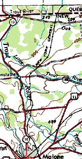
I bicycled to Canada October 23rd, 2001. There's an old railroad right of way (ROW) that goes from Malone, NY north. It also goes south. The former Mohawk and Malone, it became the New York Central more than a hundred years ago. Starting from Union Station on the east side of Malone, it goes through an old railroad yard which was ten tracks across, with multiple passenger platforms. It heads downhill to a sand quarry, where the roadbed has been removed. A twenty-foot climb down and back up gets you back on the roadbed.
Shortly after that, you get to the first railroad trestle, across the Trout River. Most of the cross-timbers (roughly 6x10 creosoted timbers) are still in place. No two in a row are missing, but some are rotted nearly in half. These have been bridged by a helpful person with some plywood planks. It was two hundred feet long, and fifty foot high. Being afraid of heights, I was very happy to have that bridge behind me.
The railroad has only been abandoned since 1980, so the railbed is in remarkably good condition. The railbed is mostly cinders, not weedy, nor have the ATVs had a chance to turn it into muck yet. It's only eroded in a few inconsequential places. It's quite a pleasant ride, with no nasty raspberries growing in the ROW as is the case just a few miles away on the Rutland mainline to the east of Malone.
The roadbed continues along, winding generally downhill along the side of Adirondack foothills. For the most part the railroad mostly runs on the top of fills. There are very few cuts along this roadbed.
I cross a couple of roads. The railroad takes a 45 degree turn to the right, and shortly comes to a thousand-foot-long trestle above the Little Trout River. I've come this far; there's no turning back now. I hold the bicycle on my right, and walk on the timbers directly over the steel beam. Six inches to my left is a sixty-foot drop. Step by step, I cross the bridge, with no fear but a curious inexplicable clamminess at the back of my neck.
I was careful to note the road crossings. I didn't want to accidentally cross into Canada. I didn't have to worry about that. The world's longest undefended border isn't so very casual that you could cross it by accident. It's a straight line cut through the woods, about 25' wide, and not brush-hogged every year. This much was obvious from the large stand of raspberries to the east of where the roadbed crosses the border.
Both sides of the railroad ROW are marked by large pillars marked on the south with "NY" and the north with "CAN". Since they are the only such, I assume that they are a reminder of the days when the railroad continued through to Montreal. Slightly to the east is a concrete pylon whose base says "US" on the south, "Canada" on the north, "No. 727A" on the east, and "Reworked 1974" on the west.
A ways off to the west was a covered stand that somebody had built of wood. I strongly suspect that it's a hunter's stand instead of a military watchpost since it looked quite temporary. Also, the deer would just *love* the border clearing.
The way home was unremarkable, except for the extremely aggressive dog that started chasing me, and after I talked to him, decided that I was his friend and wouldn't go home. After a half-mile of this nonsense I turned around and brought him back to his trailer.
This railbed is an *excellent* candidate for being turned into an official rail-trail. Nobody has had a chance to build on the railbed. It's still being used as a ROW by ATV'ers. It's really quite unfortunate that ATVs are so hard on a trail, otherwise there's no reason why anyone would object to their presence.
See also my Rutland Railroad journal