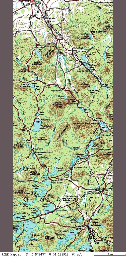
On August 17, 2000, Steve Ovaska and I rode the New York Central south from Malone to Owl's Head. I've also ridden it north to the Canadian border. There's an old railroad right of way (ROW) that goes from Malone, NY south. It's now used as a powerline right of way, owned by Niagara-Mohawk. The former Mohawk and Malone, it became the New York Central more than a hundred years ago. We started where the railbed crosses Rt. 11. We didn't go too far south before we startled a family of turkeys. North of Teboville, the railbed is fenced off as part of a cow field. It was just a barbed wire fence, but there was a farm road, so we rode out to the highway and bypassed it.
The rest of the way to Owl's Head was uneventful if uphill. We took the highway back.
On June 13, 2004, I road from Owl's Head to Inman. The bridge is out in Mountain View, but the old highway bridge works to cross the road. The topo map is quite wrong about the roads in Mountain View. The road that seems to become the railbed is apparently private property and is now fenced off.
South of Mountain View, the railbed is paralleled by Wolf Pond Road. It's initially paved, but turns to dirt before too long. The railbed is somewhat gravelly and sandy the whole way from Malone to here, but south of here is completely so. There was only one section which I couldn't ride on. The ATVers had ridden up the side of a hill and caused the sand to slide down onto the railbed.
Around Plumadore, the Chateaugay Railroad joins in with the NYC. They travel side by side through to Lake Kushaqua, sometimes as little as thirty feet apart. It is maintained as a road, at least as far as Inman. Just north of Fishhole Pond is a complicated junction, called "Tekene Junction". The Chateaugay had an overpass to a branch line heading west. The abutments are very imposing structures, as are the approach ramps to them. They show up very nicely on the topographic map. Just a couple of hundred feet south, that branch line had initially been connected to the NYC line. When the branch line was sold to a company associated with the Chateaugay Railroad, the NYC didn't give permission for a grade-level crossing, so they built a flyover of such strength and magnificence that the abutments remain to this day.
As I was on a schedule, I hopped off the railbed at Loon Lake Station, also known as Inman. The highway bridge is out, but there are nicely formed ramps down to a highway crossing.
On August 25th, 2004, I rode from Inman to Lake Clear Junction. It was a very pleasant ride, with almost no grades. All the altitude necessary to get to Lake Clear has already been gained at this point. Aside from a few interesting wide spots, a few spikes, and a few bits of concrete foundations, there is almost nothing left of the railroad. Onchiota, once a hotbed of railroading, with three distinct railroad companies operating in town, is, at least on the NYC, has nothing more than a wide spot in the trail where some sidings might have been. Close to Rainbow Lake there are signs warning ATV riders that the railbed is closed to motorized vehicles. I believe, in my cynical manner, that the ritzy property owners asked Ni-Mo to keep the ATVers out. A little bit to the south, the railbed-cum-road is drawn as if it merges with the road, however, it doesn't. There is a bit of a ramp down to the highway at that point, but there's no need or reason to leave the railbed.
From Gabriels south the railbed becomes quite boring. It's a bit of a plains in this area, so the railbed runs straight as an arrow. On the Wednesday that I was riding, I saw a car driving ahead of me. When I finally caught up to it, they had stopped where the powerline leaves the railbed. The entire width of the cleared area was blueberry bushes! I stopped and ate a few handfuls of berries. Since they were older, and might have lived through the depression, I told them about Ed Helms depression-era story. They used to have to pick berries for their dinner because they had scant money. One afternoon, a bear was on the other side of the raspberry patch. Since they would have gone hungry if they didn't pick, they picked their side, and the bear picked his side.
The railbed runs right next to the Saranac Lake airport. Interestingly, there is a brand-new chain-link fence with barbed wire on the top. Since there are woods on both sides of this fence, the barbed wire is a useless decoration. Anybody who wants to get past the fence will simply cut her way through. There's nobody to see them on either side, so the barbed wire isn't stopping anybody. For that matter, neither is the fence. Thank you, Homeland "Security" Administration.
At Lake Clear Junction, the wye present on the map is not present on the ground. There is still a switch frog sitting there, as if it was removed and then set aside for "later". With no switches, it can hardly be called Lake Clear Junction anymore.
Well, that's the end of this line. The railroad continues on to Tupper Lake, Old Forge, and ultimately Remsen. The NYC also went on the Saranac Branch into Saranac Lake and thence to Lake Placid. Also, the Paul Smiths Electric Railway continued north to Paul Smiths.