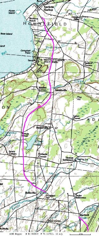

Two railroads used to run between Watertown and Sacketts Harbor. This one is the Sackets Harbor and Ellisburgh, which ran north and south. The other one was built by the Carthage Watertown & Sackets Harbor Railroad and ran east and west. You can see a small portion of it at the very top of the map above. The only railbed shared between the two railroads was the portion of the curve into Sackets Harbor starting where it turns to the northwest.
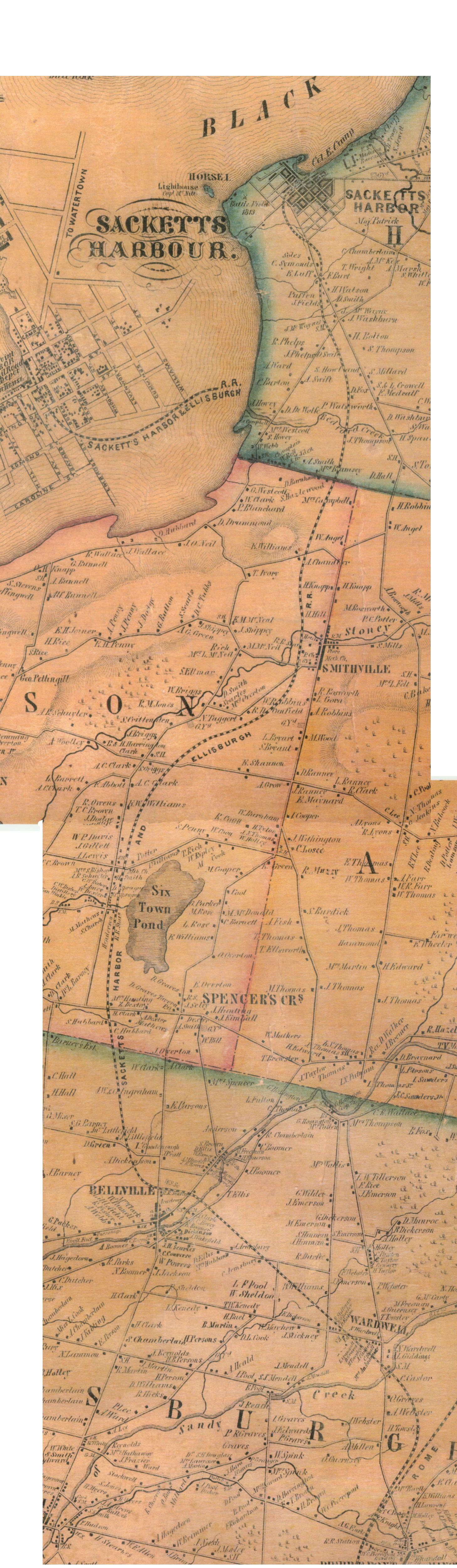
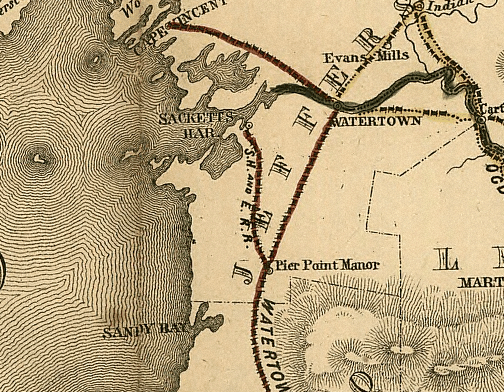
The map above left (with the purple line) uses the 1965 topographic map data. The railroad is drawn only where the map doesn't show it. The middle map above is a large scan (1MByte and 1458x5000 pixels) of a color photocopy of the 1855 map, which shows the route of the SHnE. A monochrome scan of the whole map is available on the Town of Hounsfield website. The map on the right is selected portions of the Army Mapping Service (AMS) Sackets Harbor, Henderson, and Adams quads. If you click on it, you'll get an extremely large image (640K and 2000x5500 pixels) which shows the entire route of the railroad in great detail. You can also see the originals of the AMS maps. They date from the 1940's and they show almost the entire length of the railbed. The route is also listed in OpenStreetMap.
On other pages, we have a timeline, a report of field work done in 8/2002 and 5/2003 by Russell Nelson and Richard Palmer with help from Sackets Harbor resident Bob Brennan. Shirley Farone, a Jefferson County resident, has a page with more research by Richard Palmer, covering the RW&O and the SH&E. On 7Mar2004, Russell Nelson found the roadbed to the west of I81. On 17Jul2004, he hiked up the CSX right-of-way and found the roadbed to the east of I81. He writes "Even before I got to the spot, I could see a notch in the treeline where the SH&E took off to the west." It's been perfectly preserved, being in the no-man's land between the CSX tracks and I81. You can get a strong sense of the low-investment character of the railroad. They basically pushed the rocks off to the side, scraped off the topsoil, dug some drainage ditches, and put the ties on the subsoil that remained. Since the ties were removed, and there was never any ballast, there is essentially no evidence that the right-of-way was ever a railroad.
The Library of Congress has Historic Railroad Maps from 1828 to 1900. Excellent resource! There is a section for New York State-only maps. The 1855 map shows the SH&E. You have to zoom in on it; the image below is taken from the zoomed view. You can also see the RW&O Cape Vincent line with which the SH&E was competing.
Dick Palmer found a timetable on page 82 of the American Railway Guide and Pocket Companion, Edited By R.S. Fisher, New York: Jauary, 1856:
Sackets Harbor & Ellisburgh R.R.
C.W. Bishop, Pres., Henderson.  J. Collamer, Supt., Watertown, N.Y.

Pierrepont Manor to Sackets Harbor
Leave Pierrepont Manor 9:30 a.m. 6:30 p.m.
Leave Belleville  9:46 p.m.  6:50 p.m.     5 miles
Leave Henderson   10 a..m.   7:10 p.m.     9 miles
Leave Smithville  10:16 a.m. 7:20 p.m.    13 miles
Arrive Sackets Harbor 10:20 a.m. 8 p.m.   18 miles

Sackets Harbor to Pierrepont Manor
Leave Sackets Harbor 7 a.m.  4:15 p.m.
Leave Smithville     7:25 a.m. 4:25 p.m.    5 miles
Leave Henderson      7:45 a.m. 4:50 p.m.    9 miles
Leave Belleville     8:05 a.m  5:05 p.m.    12 miles
Arrive Pierrepont Manor 8:30 a.m. 5:22 p.m. 18 miles

Railroad Connection with Watertown & Rome R.R. Pierrepont Manor. Oct. 15, 1855
Here's a list of aerial photos from north to south along the railbed of the Sackets Harbor & Ellisburgh Railroad Company. You can see how much still remains (the aerial photos date from 1995) and how much has been erased by the plow and bulldozer. Even where it has been erased by plowing, you can still see a mark in many fencelines where the railbed once crossed it.