There are many "paper railroads" in New York State. The fancy of wild-eyed dreamers, they never went beyond the paper stage. At the other end are railroads which were actually built, with ties, rails, engines, cars, and revenue traffic (although many never had enough of the latter). In-between are the unfinished railroads. They spent hard-earned money on grading the railroad, so there is archaeological evidence of their existence out in the field. This page is intended to be a complete listing of them, along with enough information to be able to find them out in the field. In some cases, a railroad company finished part of its charter, and left a portion unfinished. I list only the unfinished portion here. In other cases, a railroad company built an unfinished railroad which was later finished by a different company (such as the Geneva and Southwestern Railroad, incorporated to build a line in 1871 from Geneva to Naples. They graded the line, but work was halted by the Panic of 1873. Construction was completed in 1892 by the Middlesex Valley Railroad.) I do not list those here. The goal is to make a record of all the "linear berms and cuts" which were to have been railroads, but were never finished.
Since several of these railroads died directly as a result of the Panic of 1873, I thought it deserved a link here. The Wikipedia article says "Of the country's 364 railroads, 89 went bankrupt." Patrick Newman provides an explanation for the cause of the panic. Briefly, it was caused by an expansion in the money supply without a corresponding increase in the size of the economy, leading investors to create businesses with no hope of profits.
There is a Wikipedia page which borrows heavily from this page. List of unused railways
The railroads:
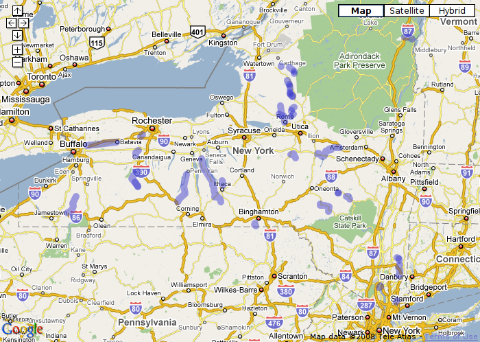
I've made a map containing all of the unfinished railroads. It can be slow to load on older computers, and may cause your browser to freeze up. It's useful to see where the railroads are relative to your location. Here's a static grab of it:
Arizona: Long ago a man named James W. Eddy had a dream to construct the Mineral Belt Railroad. The rail was to cross the state North to South. Starting in Nogales and up though Globe, then up the rim passing through Flagstaff continuing on up to the Utah border near Lees Ferry(the launching area for rafters into the Grand Canyon). In August 1883 work began on drilling a 3,100 foot tunnel to ascend the Mogollon Rim. 42 men labored all summer. After running low on funds twice the railroad was abandoned. Today the entrance to the railroad tunnel keeps the story alive.
California: Ocean Shore Railway. Substantial portions were built, some were used, but the entirety of the railroad went unfinished.
Connecticut: Rich Coffey has a page for unfinished railroads in Connecticut.
Illinois: A five mile spur would have gone to Viper Mine just north of Springfield Illinois. They bought the land and built some bridges, but built a conveyor belt instead.
Bloomington, Pontiac, & Joliet Interurban Railroad was built north of Pontiac, but attempted to build south, to no avail. There are several references to it. This search will find them.
Indiana: The Madison and Indianapolis Railroad has a 7012 foot section of track with the steepest grade of any line-haul railroad in the country, 5.89 percent. They tried to create an alternate routing with a less steep grade. After spending over $6M in today's dollars ($309,4790), they gave up, leaving a tunnel to and grade through Clifty Creek Valley, now Clifty Falls State Park. Also see the brouchure about Brough's Folly.
Indiana: Southern Indiana Railroad was to have been built in Clay County. Three bridges were begun, one finished, and 6 miles of railway were graded.
Maryland: Baltimore and Drum Point
Massachusetts and Rhode Island have the Southern New England Railway. Also the Lancaster Railroad, also called the Lancaster & Bolton, had one train run over its tracks, then was dismantled. Also discussed on railroad.net in another thread as well.
In Massachussetts, The Hampden Railroad ran between Bondsville, Massachusetts and Springfield, Massachusetts at Athol Junction. It was built to be an inland connector between the New Haven line and the Boston & Maine (Central Mass. division), shaving 3 miles (4.8 km) off the usual trip from Springfield to Boston. The Hampden rail line was 14.8 miles (23.8 km) of high class rail that never felt the wheels of a single revenue train, just two inspection trains.
Massachusetts Central Railroad, as originally graded. Via Railroad.net
Michigan: The Iron Range and Huron Bay Railroad was completed for 42 miles, but no train was ever operated. It got killed by the Panic of 1893, and then could not be operated profitably because the iron mines started to play out.
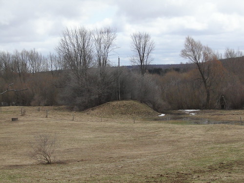
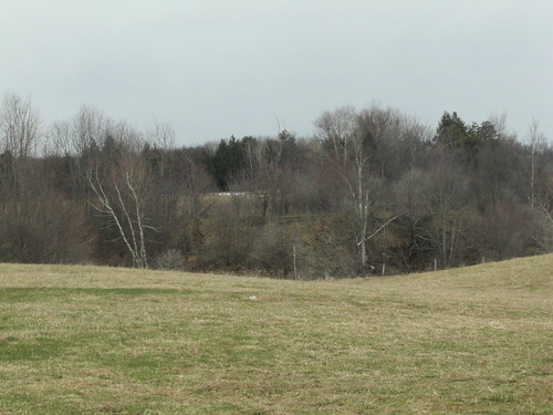
Missouri: Lexington, Lake, and Gulf was graded through Mount Hope, Missouri. The C&A built about a mile north, and not only was the LL&G discontinued, but so was the town of Mount Hope. Most houses were moved to Odessa, MI. Seems to be more information in a paper entitled They never laid a rail--: A history of the Lexington, Chillicothe and Gulf Railroad, later called the Lexington, Lake and Gulf Railroad. 1st street, in Odessa, Missouri, used to be a railbed even before the town was built. "I had always wondered why this was 1st, yet the business district was centered on 2nd. Also, I'd like to point out how level this street is, with its grading and such, when no other streets are done this way." The answer is that this was the graded roadbed for the LL&G. This was built here before Odessa was ever platted, thus, the grade was used as the basis for a street, but until the question of ownership could be resolved, they didn't dare build the business district on it. -- Randy Volskay, posted to Abandoned Rails
Missouri: The things you think you know! Chalk another under the "started, but never completed" file, in west central Missouri. I've seen these berms, along the Blackwater River, but always "assumed" (I know, I know) they were simply a flood control levee system. A recent post, in our historical society page, mentioned the Warrensburg and Marshall Railroad, started in 1870, to connect the two named towns. Initial subscription was apparently brisk, $100,000 was raised by Johnson County, with individual subscriptions in addition to that amount. The raised capital was used to grade approximately 13 miles of roadbed, north from Warrensburg. Once a couple of features were pointed out, it wasn't hard to find a couple of other locations, including a county road built for a short stretch on the old ROW. No maps are known to exist, and much of the route has been developed. I'm planning another jaunt through that area this Fall, when foliage is down. Maybe more of the route will be discernable. Of course, there's no way of proving it, but I suspect this venture made the county unwilling to put up bonds on the later (and also never completed) Lexington, Lake, and Gulf Railroad. Old certificate photo is from the Johnson County Facebook page. --Randy Volskay, Facebook post
Missouri: Between Greenfield and Springfield, Missouri lies The Kansas City & Memphis Railroad. They started grading between Springfield and Greenfield, but got caught by the panic of 1873 and went bankrupt. This PDF is a biography of someone who "had the contract for grading five miles of the Kansas City & Memphis Railroad. After completing one mile the company raised the grade, and Mr. Murray threw up the job." It's out of my purview, but I think I found two chunks of it: West, and East. It looks plausible after staring at the topo map. I found a couple of "grading" lines on the topo map, and some very clear treelines and field shadows. Too far for me to ever do fieldwork on it. Hat tip to Mike Murray, who pointed me at this.
New Jersey: Westville Cutoff. Also, the Millstone and New Brunswick Railroad was to have been extended, and the bridge piers placed.
New Jersey: The Rockaway Valley Rail Road intended to expand its trackage to Morristown. They graded the railroad, but never laid tracks.
New Jersey: This bridge was built for the railroad to cross US-206, but the DL&W abandoned the Sussex Branch before track could be laid on the bridge, so it has never been used as a railroad bridge.
New Jersey: The Erie's Morristown Branch: routing, railroad.net thread, John Monteningo's article. The Erie Lackawanna Historical Society records. Various bits of evidence for it: a line of new houses built along streets in Montclair, built after the Erie gave up on building out this railroad. Tunnel Brook runs through a cut that was to be a tunnel approach. Tierney's Tavern in Montclair has a corner cut off the back of it, necessary to stay clear of the right-of-way.
New Jersey: The Ogden Trail in Tourne Park, Boonton NJ area, Morris County NJ, was a spur track that was graded but never saw rails.
New Jersey: New Jersey West Line.
New Jersey: The Lehigh & New England owned a right-of-way that went underneath the New Jersey Lackawanna Cut-off. They never built-out that right-of-way, but the Cut-off has a tunnel to preserve the right-of-way. It's in Tunnel Park.
Oregon: The Oregon Pacific Railroad (the 1880 one, not the current one) was to have gone from the Oregon coast to Idaho through Santiam pass. They made it as far as Detroit OR, but only graded beyond that. Two little sections of railroad were finished. They laid track through Santiam Pass to legally cross the Cascade Mountains and in the Malheur River canyon to reserve the pass for themselves.
Ohio: Four unfinished railroads: the Mansfield, Coldwater and Lake Michigan Railroads, the Chicago and Canada Southern, the Toledo, Ann Arbor and Detroit and the Clinton Air Line Railroad ("Work was begun on the Clinton Air Line, a railroad, which had been partially constructed between New London, in Huron County, and Republic, in Seneca County."). Also see The Firelands Pioneer for more information on the Clinton Air Line Extension Railroad.
Ohio: Lake Erie & Pittsburgh. More information on Abandoned Rails on Facebook. LE&P. Much more information on OhioRR.
Ohio: The South Bloomingville Railroad operated from Lancaster to South Bloomingville. They graded an additional four miles but never laid tracks. A part of the old embankment now is used as a right-of-way for Route 56 near the Scenic Inn. Also, Cincinnati had a subway attempted. Seven miles were tunneled, bridged, or graded, but no track was laid and no subway cars were ordered. Most everything above ground has been bulldozed, but there are two miles of subway tunnel left. More information at Cincinnati Transit.
Ohio: Cincinnati Western RailroadStandard gauge railroad graded between Cincinnati and Indiana in the mid 1850s. There is a tunnel underneath Roll Hill which was begun but not completed.
Ohio: Deer Creek RR Tunnel. Partially constructed. Approximately 3,500 feet of a 9,000 feet tunnel were dug.
Ohio: In the early 1850’s, the Springfield and Mansfield Railroad Company developed a plan to build a rail line from Springfield east to the City of Delaware and then on to Mount Vernon through Brown, Kingston and Porter Townships. This proposed line had several other names including the Springfield and Delaware Railroad, and Springfield, Delaware and Mount Vernon Railroad. Financial problems plagued the company and with more direct routes available from Cleveland to Cincinnati, the plan for the Springfield to Mount Vernon rail line was abandoned reportedly in 1853.The company was sold in 1862 to the Cleveland and Columbus Railroad. The proposed route would have taken the line through Eden (which is now Kilbourne) and Olive Green. To finance the project, the railroad attempted to have local townships back the sale of government bonds. According to a local account, the railroad did approach the Brown Township Trustees to back the bonds in the railroad (whether they or Kingston Township financially backed the bonds is not known), and according to Kingston Township Road Superintendent Doug Crowl, bonds were backed by the Porter Township Trustees. After the railroad project was abandoned, the township was sued by a lending institution located in Toledo, Ohio. This lawsuit eventually ended up in the Ohio Supreme Court in 1884 who (we believe) upheld the appeals court ruling that the township was not responsible for the bond cost. It is not known whether any tracks for the railroad were actually laid. If anyone has knowledge about whether tracks were installed, please let us know. Today, there are several places where remnants of the failed railroad can be seen. The best remnant of the raised rail bed is the mounded area located on the east and west side of Blue Church Road just north of State Route 521 at the creek. Raised remnants can also be seen on the north side of State Route 521. The raised rail bed is located just inside the wooded area at the back of the farm field across from the white house and barn just west of State Route 61. For the adventurist, a stone bridge abutment still exists where the proposed railroad was to cross Alum Creek south of State Route 521in Kilbourne. The abutment is located within Alum Creek State Park and public parking is available on the south side of State Route 521. The abutment is about one quarter mile downstream of the parking lot toward the lake. -- Jeff Hutt on Facebook.
Pennsylvania: The famous Unfinished Cut that played such a big part in the Second Manassas battle of the Civil War.
Pennsylvania: The Allentown Railroad (route: https://www.openstreetmap.org/way/146156452).
Pennsylvania: The South Mountain Railroad.
Pennsylvania: The "Petroleum & Pennsylvania Railway, whose grade is now Old Grade Rd. in Clappville, Steuben Township Crawford Co."
Pennsylvania: The Delaware Valley Railroad was built from East Stroudsburg to Bushkill, but was graded all the way to Milford. Also, the Milford and Matamoras Railroad was proposed, and a bridge built across the Delaware and tracks run down to a gravel quarry along Avenue C. .
Pennsylvania: In Philadelphia, Arch Street has a subway tunnel underneath it that was never finished and never used.
Pennsylvania: PCC: Ghost Plane (Old Plane 12) at Lost Trails ATV park. The PA Coal Company Gravity Railroad lead from Pittston to Hawley PA where coal could be unloaded onto boats of the Delaware and Hudson Canal. It operated in this fashion from 1850 until 1885 when it was replaced by a steam railroad. These inclined planes operated with stationary steam engines, rather than scotch turbines like the ones everyone is more familiar with on the Morris Canal.
The original plane 11 is just to the north of the second plane #11; plans were to construct another plane just above, but when it was decided to tunnel instead, the rail line turned south a bit and the partially constructed plane 12 was abandoned, unfinished. It was decided to straighten the line and a new plane 11 was built around 1870.
Pennsylvania: The Reno, Oil Creek & Pithole railroad was built and operated from Reno to Plumer and then graded to Pithole, but no tracks were laid to that town. An article about Mr. Smithman discusses this railroad.
South Carolina: The Blue Ridge Railroad was to go through the mountains of northwest South Carolina. They got as far as Walhalla before running out of money. They graded past that, and built three tunnels: Saddle Tunnel (partially completed and mostly submerged by a small lake), Middle Tunnel (mostly collapsed and partly sealed off), and Stumphouse Mountain Tunnel. The latter was only partly completed and is now part of a public park. Visitors are encouraged to enter the tunnel. There is a book on the railroad entitled The Rocky Road to Nowhere.
Tennesee: The Southern Railway's Stevenson Extension was never finished. It went from Chattanooga through new Lookout Mountain tunnel, along today's Highway 41 by the river, cross the river near Orme Island not far from Haletown, then go by South Pittsburg and on to Stevenson. A local newspaper as two articles on it: Part One, Part Two, and Part Three.
Virginia: Between Lexington and Salem. "Iron Horses in the Valley", by Hildebrand covers this railroad. Also see an unfinished bridge. http://www.abandonedrails.com/Valley_Railroad
Virginia: Routing and remains, The Unfinished Manassas Gap Railroad.
Wisconsin: Five blocks of unfinished trolley tunnel in Milwaukee.
Washington: There is a tunnel underneath Tacoma that was never finished. The Union Pacific ran into large flows of water, and ended up getting trackage rights from a competitor. They tried to leave the tunnel unfinished, but the water flows continued to erode the tunnel from the inside out, and they eventually had to backfill it. However, the water continued and continues to flow, and continues to erode the fill.
Australia: The Orphan Rocker was a roller coaster originally envisioned as a monorail. It was never opened to the public.
Australia: The Maldon – Dombarton railway line is a partially constructed railway line in New South Wales, Australia. Construction commenced in December 1983 with the project being cancelled in June 1988.
Canada: Port Nelson was to be a town, railway, and port, and ended up as none. There is a railroad bridge out to an offshore artificial island that has never been used.
Canada: Built under the charter of the Alberta Midland Railway, a Canadian Northern Railway (CNoR) subsidiary, a line was planned south from Calgary (Inside Calgary city limits), into Fort MacLeod, then south then west to a point on the map called Fishburn -- today called Twin Butte -- a proposed town, but never more then a crossroads.
Canada: The Toronto and Ottawa railway was reorganized in 1881 from The Huron and Quebec Railway. 8.5 miles were graded between Actinolite and Madoc Ontario.
Canada: The Dease Lake Extension aka the Stuart Subdivision aka the Takia Subdivision was never completed, although the southern end of it was operated as the Takia Sub.
England (Derbyshire, East Midlands): The Clay Cross Company intended to build a colliery at Mickley, and graded a railbed, but only a portion of it was ever used, as the Mickley Branch.
England: The Ouse Valley Railway. The Whitewicks did a video on this unfinished railway.
Portugal: Aljustrel, in the south of Portugal... railroad to mineration plant. Tracks built but never used.
Russia: There's an unfinished railroad in the Russia. 370 miles of it(!). Built with slave labor, it was never completed betweeen its two ends. Unclear from the news account of the Railway of Bones whether any portion of it was ever used. Also see Stalin's Lost Railway.
Spain: PLATAFORMA VIA VERDE DEL RENACIMIENTO, begun in 1964, mostly completed, but never put into service. Now parts of it are a rail-trail.
Spain: The Santander-Mediterranean, also sometimes referred to as the Calatayud-Cidad Dosante line,was a Spanish railway project from the early 20th century that was never completed. It was intended to unite the maritime ports of Santander and Valencia by means of a railway connection, thus giving maritime outlet to the goods coming from the inland provinces through which the resulting railway was expected to circulate. The planned Santander-Mediterranean transversal corridor would be made up of two railway companies. The first was the Compañía del Ferrocarril Central de Aragón, owner of the Calatayud-Valencia line, and the second was the Compañía del Ferrocarril Santander-Mediterraneo, which would build the planned Calatayud-Santander section. In the initial projects, the connection in Santander with the narrow-gauge Astillero-Ontaneda railway was also planned. By the end of 1930, the construction of the route between Cidad de Valdeporres and Calatayud had been completed, but the works would be paralyzed at that point for the following years. After the Civil War, the Franco regime revived plans to complete the line and began construction work in the province of Santander. However, in 1959 the entire project was paralyzed by the regime and was never completed. The part of the railway that was completed, 367 km long,was operational between 1930 and 1985. After the end of the Civil War, in 1941 the route was integrated into the network of the recently created RENFE , who maintained its exploitation during the following decades, with a languid existence. In January 1985 the line was closed to traffic in its entirety and years later the lifting of the track would be decreed. Only some small sections of local character have remained in service, while others remain abandoned or have been adapted within a large greenway project. On this unfinished line, the La Engaña tunnel, 6,976 m long, has until recently been the longest Spanish railway tunnel. The line was not completed with only the last 50 km remaining to be put into service, leaving only the installation of the rails, taking into account that all the stations, bridges and tunnels had been built.
Vietnam: I found this mention of an aerial tramway was used in place of an unfinished railroad: "The 16km stretch of railway line built on Lao territory incorporated two viaducts and four stations. Thakhek (km 0), Ban Tham (km 7.44), Ban Nam Don (km 10.3) and Pha Vang (km 15.59). However, although construction of the Lao section is known to have reached an advanced stage, there is no evidence that it was completed or that trains ever ran on it."
Unfinished canal bits in New York State:
I have very little information on the Adirondack Railroad. My only source is a page on the Ticonderoga Branch. It says:
McIntyre and Henderson had a problem. They had the ore, furnace, limestone, charcoal, and the plant to make iron, but how could they get the iron out of the region? A railroad seemed like the obvious solution. The two entrepreneurs formed the Adirondack Railroad in 1839. This line extended three miles from the McIntyre Iron Works to absolutely nowhere. The company entertained other ideas, but Henderson, the life of the project, was accidentally shot and killed at a place today called Calamity Pond.
A description of the railroad and associated laws is in The Statute Railroad Laws of the State of New York: Codified and Arranged. Adirondack Railroad (No 1 Adirondack Iron Works to Clear Pond now part of Adirondack Railroad) Incorporated, 1839, chap 120. Time for completion of road extended, Laws 1862, chap 90; Laws 1865, chap 60. Aid to Laws 1868 chap 236; Am'd Laws 1868, chap 718; Laws 1871 chap 857. May extend road, Laws 1865, chap 250. Lands of, exempt from taxation, Laws 1868, chap 850.
I've found a bare mention of this railroad on Phil Goldstein's railroads page. It's also known as the Delaware Valley Railroad. He cautions against using the information as the sole reference, which of course means that it's more reliable than if he didn't say that, because it means he's aware of the problems. He gives 1898 to 1899 as the dates of the railroad.
The New York Times article of January 15, 1898 tells of a Delaware Valley Railroad, but this one is go to Bovina Centre. Michael Kudish, and earlier, Burr Hubbell, told me in private email that there is grading to Bovina Centre.
ALBANY, Jan. 14--The Delaware Valley Railroad Company was incorporated to-day, with a capital stock of $150,000, to operate an electrical road from Delhi to Bovina Centre, Delaware County. The Directors are Henry Davie, J.R. Honewell, S.P. Wil- bur, and George W. Youmans of Delhi; James F. Scott and W.C. Oliver of Andes; Herbert F. Sewell of Dalton, and Alexander Wilson and T.E. Hastings of Bovina.
The Buffalo Extension of the Atlantic & Great Western Railroad Company was to have been built from Randolph to Buffalo. In 1864, the A&GW began grading a railbed through Napoli, New Albion, and Otto. I have no route information at this time, but by the published descriptions, it must have gone through those towns (but that route is extremely approximate). The Western New York Railroad Archive has more information about this railroad. They say that the grading was ten miles, but the route that they have indicated is seventeen miles long. The railroad shows up on an 1865 map forwarded to me by Tom Starr:
Georges Dodds found a story about the Zoar Valley that mentioned the A&GW, saying "In about 1865, the Atlantic and Great Western railroad was planned to cross Zoar Valley near the North Otto Road. The approaches to the bridge were built and most of the grade work was done up to Collins Center before the project was abandoned. Small parts of the grade still remain."
The Buffalo, Attica, & Arcade intended to go northwest from Java Center to Buffalo. They never made it. But you can find the wye at Java Center, and some of the roadbed along Route 78.
Pictures and video are on Flickr in my BA&A Buffalo Extension album
Dick Palmer (He's everywhere! He knows everything!) says that the Black River & Utica made an abortive attempt to run their railroad along the upper route, past Talcottville. I only have a small section of the route that the Sapbush Run says was graded past Boonville. More information will have to come from local people or a field trip on my part.

The BH&E was to have gone from Connecticut through Hopewell (just Hopewell; Hopewell Junction was still in the future) to Beacon at Dennings Point. They accomplished much of the grading, and had just begun laying track at Hopewell when, in 1870, the railroad failed. It was reorganized as the New York & New England, and (mostly) completed by them. A small graded but unfinished portion is visible as:
More information is available from the Fishkill Landing page and Dutchess Junction page. Assistance from Bernie Rudberg and Jim Heron acknowledged. Corporate archives of the BH&E are at the University of Connecticut.
After a site visit on 25th September, 2009, I was able to trace the ND&C line to the high embankment leading to the bridge pictured above. Unfortunately, I couldn't see any sign of the pilings out in the Hudson. On a later visit in October, I suspected that I had found a grade on the east side of the point. On that visit I purchased Jim Heron's book on the History of Denning's Point, and found that yes, the eastern side had in fact been graded. Further, the caretaker's house was originally the headquarters of the BH&E. According to Jim, the pilings have rotted away such that they are never visible, even at low tide.
Three railroads in this photo of Denning's Point. The obvious one runs north south, is the Metro-North line just south of Beacon, NY, and isn't abandoned. Trains every hour (at least); not at all abandoned.
The second railroad is the Newburgh, Dutchess, and Connecticut. It ran along Fishkill Creek, on the south bank, and connected to the Metro-North line on the east side facing south. On its other end it connected to the Beacon Line, which connected to Metro-North on the west side facing north. The Beacon Line is out of service, but not (yet) abandoned.
The third railroad was The Boston, Hartford, & Erie. They did quite a bit of grading, but never laid any track and went bankrupt. Their railbed was later used to build the ND&C in this photo. The Erie was on the west bank of the Hudson in Newburgh. You'd need a river port and car ferry to connect to it (which the ND&C had, which is now Long Point Park). And indeed, that is what the BH&E started to build, but never finished. They built a bridge over Metro-North, and they built a trestle over the bay to Denning's Point where they were going to cross the island and go out on a long pier to load up the car ferry.
This photo shows the ruins of the trestle. You can't see the pilings anymore, not even at low tide. They may even have rotted away far enough that they're not a navigation hazard, although they're still on the charts as such. But the green growth in the bay reveals the trestle as a dark line across it.
I just recently found out about two railroad bridges that were planned and/or construction begun over the St. Lawrence River. One was at Morristown, heading for Brockville, with abutments that remain on an island mid-way but still in Canada, called the "Brockville & New York Bridge Company". The other was at Waddington, which would have head over to Morrisburg, called the "Ottawa Waddington & New York Railway & Bridge Company". To avoid confusion between Morristown and Morrisburg, let's call them the Brockville bridge and the Waddington bridge.
I'll start off with some links: Waddington Stock Certificate
Waddington charter renewed and announced in the Norwood News
Waddington chartered for 20 miles in 1884: https://books.google.com/books?id=DlsaA ... on&f=false
Note that the Norwood and St. Lawrence Railroad didn't get to Waddington until after 1910, so this proposal included a railroad from Waddington to Canton.
Local Railway Items from Ottawa Papers
Engineering News and American Contract Journal, Volume 13: " Another Bridge Across the St Lawrence bridge across the St Lawrence making three the Canadian Pacific's contemplated one at is projected by the Ottawa Waddington and York Railway Company the site to be at Gooseneck island The bridge over the main channel Will be feet long and will be divided into four spans of 200 to 250 feet the third span from the south shore a span of 250 feet and a clear height above the of forty four feet.
From the 1885 Oswego Daily Blade:
A Bee-line Kailroad from Ottawa,
Canada, to
Schenectady, N. Y.
NEW YORK, May 6. An important
meeting
of railroad men was held in this city
yesterday
afternoon. They were the officers
and stockholders of the Ottawa,
Waddington
and St. Lawrence River Railroad and
Bridge
company and the Canton and St.
Lawrence River Railroad and Bridge
company.
These companies have been formed
for more than a
year with the object of constructing
a bee-line road from
Ottawa,
Canada, to Schenectady in this state, their
work to
include the bridging of the St.
Lawrence river. No part of the
roads ha:
as yet been constructed, everything having
depended on obtaining the permission of the
United States to
construct the bridge.
The road in Canada, running from Ottawa
to Waddington, on the St. Lawrence river,
is 52 miles in
length. In aid to its construction
Ottawa has subscribed $160,000
and the
Canadian government has given $3,200 per
mile for
the 52 miles. Both amounts are to
be used for the payment of the
interest on
the bonds issued during construction. The
bridge
will be an elaborate piece of work and
the only one crossing the
St. Lawrence except
the Victoria bridge at Montreal. It will
be 1,000 feet in length, and will be constructed
at Goose Neck
island, about 21 miles
below Ogdensburg. It will contain two
draws, one each side of the island. From
tins point the line
runs direct to Canton,
St. Lawrence county, and from there
follows
the old New York and Schenectady railway
survey
straight through the Adirondack
wilderness to Schenectady. The
line through
the wilderness runs along the lake region,
thus
finding an easy grade and no tunneling.
The Canadian company are
to construct
their part of the road to Ooose Neck island,
and the remainder will be built by the United
States
company. Each draw of the bridge
is to be about 350 feet
long. The line will
save, it is claimed, nearly 200 miles'
travel,
as compared with the present mode of reaching
Ottawa, It will connect with all the
roads running west in
Canada.
More pictures in my Flickr Brookfield Railroad set.
Brookfield Railroad, connecting Brookfield and North Brookfield, graded in 1888. Dick Palmer pointed me to this one. An 1875 county map of Brookfield doesn't show any railroad.
Did some field research on 9-Apr-2010. Got HUGE help from Doug
Keith, who curates the railbed on his property. Also have a map from
the Madison County Clerk's office:
Click on
the map for a full-sized (1.3MB, 12000 x 4640) image. It's a really
BIG image which might crash your browser. Consider yourself
warned.
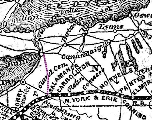
The Buffalo, Corning and New York railroad actually had tracks from Corning to Batavia, and graded westward, but never laid tracks. On Railroad.net, nessman says that the finished portion later became part of the Erie, with tracks as far as Tonawanda Creek before heading south to Attica, and that it wasn't finished due to bankruptcy. There's a discussion on Railroad.net under the subject What was the "Old Conhocton Roadway" (Batavia-Buffalo)?.
Salminkarkku (a railroad.net username) points out the existance (however slim) of the BTI&P railroad. It was intended as a bridge between the LV, RW&O at Tonawanda Junction and Buffalo. He says that the ICC listed it as operating 50 yards in 1908-9. From the various bits on Google Books, it seems it was acquring land up to 1911 when it gave up and sold its properties to the International Railway, an interurban. It seems to have done this at the Suspension Bridge end.
The railroad is described in having not been built in 1905 where the Senate of the State of New York talks about various railroads being required to eliminate grade crossings.
The New York Times reported the chartering of the railroad May 21, 1890.
The New York times reported on December 30, 1890 that "The only alternative (to reach Buffalo) was to build, and for that purpose the Buffalo, Thousand Islands and Portland Railroad Company has been formed, to build from a connection with the RW&O at Suspension Bridge to Buffalo, a distance of about twenty-five miles. A large portion of the right of way has been acquired and the line leased by the RW&O."
They further pointed out on March 20, 1891 that after the RW&O was acquired by the NYC on March 15, 1891, the options were allowed to expire, and speculated as to why. On March 27, 1891 they printed further speculation that the road would be built by the Lehigh Valley even if the RW&O / NYC had no interest. On April 8, 1891, they reported their belief that the Lehigh Valley would be accommodated via other NYC lines. Thus died the BTI&P.
The Burt Line railroad was to run across the state. The only portion of it that I have found to date is a short section west of Canastota, but Mike Colangelo says he found some in Oneida.
Quoting from an article in the Chittenango NY, Madison County Times, April 14, 1939 issue, "Actual work on this line was started and considerable grading was done in the vicinity of Lenox avenue, Oneida. The proposed road bed is still plainly visible north of the West Shore between Lenox Avenue and Sayles Street. At Sayles Street the line swung to the south to touch Kenwood"
Quoting from an article in the Rome Daily Sentinel, Thursday Evening, April 26, 1906, under "Westmoreland Waftings", "Surveyors Locating Boundaries of Old Burt Line Railroad". Hecla, April 26 - Surveyors of the Central Railroad are locating the boundaries of the old Burt line railroad, which became the property of the New York, West Shore and Buffalo Railroad Company, when the latter was organized some 20 odd years ago. This line runs from here west to Canastota, midway between the Central and the present West Shore line, and the object of the survey is the fencing in of the route. In fact, some part of the fence line, are actually being built. The strip is 66 feet wide and runs through many farms and pastures, the owners of which will be greatly inconvenienced by these fences, for they have been allowed the use of these lands for many years, although the Central company has paid the taxes regularly.
Cooperstown & Charlotte Valley was built from Cooperstown to Davenport Center, and was to be built through Harpersfield, to Cooksburg, which was the northern terminus of the Canajoharie & Catskill. Some portion of the grading was done up the valley of Charlotte Creek well into Harpersfield Township. Work ceased in 1890. Information from a Railroad.net thread.
Cooperstown & Northern
The Danbury and Harlem Traction company was a proposed trolley line to connect Danbury, Connecticut, with the New York Central Railroad station at Goldens Bridge, New
Cooperstown & Northern
The Danbury and Harlem Traction company was a proposed trolley line to connect Danbury, Connecticut, with the New York Central Railroad station at Goldens Bridge, New York. Established in 1901, a short section was graded from the Danbury Fairgrounds, west through Ridgebury, Connecticut, and eventually just across the state line to North Salem.
Rich Coffey has done a fine job of researching this line and writing the description above.
The Delaware and Eastern was chartered to build between Wilkes-Barre, PA and Schenectady, NY. It was built between the East Branch of the Delaware near Hancock and Arkville, went bankrupt in 1911, and reformed as the Delaware and Northern, and run with diminishing success until 1942.
I've found a bare mention of this railroad on Phil Goldstein's railroads page, with no route information given. He cautions against using the information as the sole reference, which of course means that it's more reliable than if he didn't say that, because it means he's aware of the problems. He gives 1907 to 1910 as the dates of the railroad.
The Delhi & Middletown was to go from Delhi to Arkville and connect with the Ulster & Delaware, but it got caught in the Panic of 1873. Route information is courtesy of Burr Hubbell. Lots more information on Ross Horwood's site (he let the domain name lapse, so best to get it from the archive.org copy). The NYTimes article of April 20, 1888 states:
Not able to repudiate its bonds.
A New York town which has to pay $250,000 for trying to aid in a railroad scheme.
Middletown, N.Y., April 19. - The decision handed down by the Court of Appelas Tuesday, in the case of Malcolm Calhoun and twenty-five other taxpayers of the town of Andes against the Delhi and Middletown Railroad Company and others, finally terminates in disastrous defear the stubborn effort made by the citizens of Andes to repudiate its bonds issued in aid of the construction of the defendant company's railroad.
Andes is an isolated farming town in the highlands of Delaware County. When, in 1870, the line of the Delhi and Middletown Railroad Company was surveyed through the centre of the town--a line that was to connect the Ulster and Delaware Road at Arkville station with the Delhi branch of the Ontario and Western Road--the taxpayers were induced to bond the town for $100,000 in aid of the construction of the road, which bonds, issued for thirty years at 7 per cent interest, were turned over to the Directors in exchange for a like sum of the company's common stock.
The work of building the projected road was begun in 1871, and during that and the following year as so far prosecuted that about thirteen of the thirty miles contemplated were partially graded and bridged. Then the funds gave out and work on the line was abandoned. In 1881 the property and franchises of the original company were sold, under foreclosure of a mortgage held by the National Trust Company of New York, to a new company, styled the Delhi and Hudson River Railroad Company, with Thomas Cornell as President, and Thomas C. Platt, William C. Sheldon, John S. Martin, and Daniel B. Halstead, of new York, and other prominent capitalists as Directors, but the new company has never made a move toward completing the road.
The town of Andes for the first few years paid interest regularly on its bonds. But when, in 1881, the foreclosure sale wiped all value out of the company, suit was brought to declare the bonds void on the ground that the town officers had failed to comply with certain provisions of the Town Bonding act of 1869. The decision of the court practically condemns the town to pay about $250,000 in bonds, interest, and costs, for which no equivalent has been received.
The Delaware & Northern had a branch line to Andes which was supposed to continue through Little Delaware to Delhi, and was partially graded (this may have been a later effort to get to Delhi). Conversely, Burr Hubbell tells me that it was the D&M which had graded past Andes towards Margaretville, and which the Delaware & Northern later used for their Andes Branch. So it was likely the Delaware & Northern which was aspiring to use further the existing D&M grade rather than having done their own grading which went unused.
Phil Goldstein gives the route as Delhi - Andes - Union Grove - Margaretville - Dean's Corners (R&O) and notes that grading was started but not completed. That follows the same route as the Delaware and Northern built for their Andes branch. I don't know where Dean's Corners is supposed to be, but it must be very close to Arkville.

Dunderberg Spiral Railway. It was built on Dunderberg Mountain, now a part of Bear Mountain State Park. A gravity railroad built as an amusement ride. The canonical information on it is Joe Brennan's Dunderberg Spiral Railway page, including the photo below. Also some nice photos of the two tunnels at The Lonesome Hiker's blog.
A dozen or so photos taken by Rich Kugel are on NERail.org. Also see my album: Dunderberg Spiral Railway.

The Elizabethtown Terminal Railroad was incorporated in 1909 to construct a spur line to Elizabethtown from the Westport train station but the rails were never laid. NYT article on June 12 1910 says that it is to be an electric railroad, built to bring in summer visitors, and that the grading was half completed. An article 6 days later said that Vincent R. Coon was the general manager of the ETR. George Levi Brown was one of the organizers.
In this
thread on Railroad.net, WShore4Ever points to the existance of an
unfinished railroad from Richfield
Springs to Ft. Plain. I found the railroad on a scan of the
Annual Report of the Board of Railroad Commissioners of the State of
New York for 1895, published by NYSED here
 .
.
The 1883 Report of NYS Railroad Commissioners has an entry concerning the New York, Richfield Springs and Cooperstown Railway Company. Articles of association were filed Dec 15 1882. The railroad to be "commencing at or near Ft Plain, in the county of Montgomery, and running in a southwesterley direction to Richfield Springs, with a branch to Cooperstown, through the counties of Montgomery, Herkimer, and Otsego. Length of road, 32 miles. Capital stock, $600,000."
A March 29, 1884 article says "The matter of securing the right of way for the proposed new railroad from Fort Plain to Richfield Springs is nearly settled. It is now confidently held that work will be commenced at once and vigorously pushed during the Spring so as to catch a share of the Summer traffic." A July 12, 1887 article said that the charter was granted in 1882, but for lack of interest among property holders along the line the project progressed no further than the right of way and the survey".Via Rootsweb
From The Otsego Republican, August 20, 1890, Vol. 62, No. 1,
page 3 (a Cooperstown NY newspaper):
Richfield Springs and Fort Plain Railroad.Two meetings in the interest of the proposed Fort Plain and Richfield Springs road have been held at Springfield Centre during the past week. On Wednesday last an enthusiastic meeting was held when the greater part of the right of way was guaranteed. This meeting was adjourned until Monday at which time Mr. A. E. Davis of New York, agreed to have the road built by June 1st next, if $75,000 of the mortgage bonds would be taken, with the right of way given. These requirements were accepted by the meeting, which said that the bonds would be taken and the right of way given. Those interested in the project say they look forward to the immediate construction of the road. A party of engineers will go over the route at once.
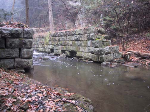
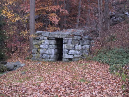
The New York Times has several articles. A September 28, 1890 article reports that "The Citizens of Fort Plain, N.Y., have subscribed $10,000 to purchase the right of way through the village of Minden and conclude the route between Fort Plain and Richfield Springs for a new railroad twenty-three miles long. The right of way has been secured between the terminals." A July 28, 1892 article says that they were determined to complete the railroad, after having spent $18,000 on franchise fees and surveys. A March 24, 1903 article report flooding, saying "The greatest damage was to the proposed railroad between Richfield Springs and Fort Plain. Hundreds of feet of the roadbed were washed out and the abutments and partially completed bridges and retaining and reinforcing walls and spiling ruined.".
Jim Loudon is a historian with the Leatherstocking Railway Historical Society. He wrote an article on this railroad and did the site surveys to determine how much is left. He reports that the entire line was graded and the ties were waiting in Ft. Plain for the rails when the company went bankrupt.
Pictures at Fort Plain & Richfield Springs (Set). Here's a picture of a footbridge that someone built on the FP&RS abutments and pier. You can see the damage described in the paragraph above:
Henry Sommers and Marcus Crosby brought my attention to the French Grade, so-called by locals, who say that it was being built by the French from Binghamton to Montrose, PA but was interrupted by WWI. Part of it is listed on the 7.5' topo maps as an Old Railroad Grade. Interestingly, it's also on the old topo maps, but as a road, not a railroad. The Northern Electric trolley is now part of the Lackawanna Trail, although no part of the French Grade is accessible to the public.
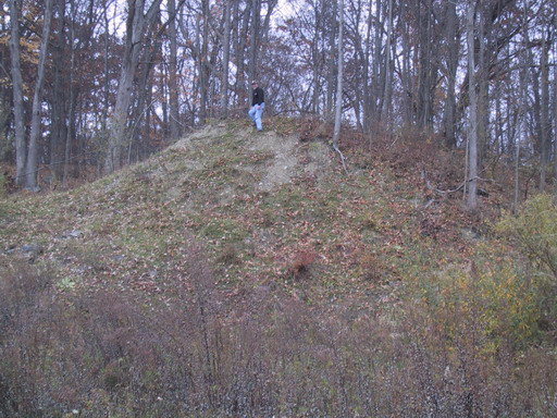
The Hasenclever Iron Mine, in the Hudson Highlands in Harriman State Park, was going to have a narrow gauge railroad to carry the ore out to a furnace. Was never finished. Barely begun; just a few hundred feet. David Bernstein visited the site and snapped a photo of a cut.
The residents of Cold Spring wanted all the benefits that would accure to people living on-line (just as people today want high speed Internet, not the old horse-drawn modems). They only had to build from there to Hicksville, where the Long Island Rail Road had its Montauk Point track. They gathered together the funds to build the railroad to Syosset, and to grade it most of the way to Cold Spring. Unfortunately for them, the tracks never got laid beyond Syosset, and Cold Spring never did get on-line.
First noticed this discussed on railroad.net in a discussion of a Mystery Grade in Cold Spring Harbor / Original LIRR ROW. They have some nice photos there, along with some discussion. That, in turn, points to AArt's Archives discussion of the H&CSBRR. One of the references in Google books in that discussion in AArt's is Hinsdale's History of the Long Island Railroad Company, 1834-1898.
According to one author, Vincent Seyfried, in 1867, they continued the grading and laying of track a little over one mile north to White Oak Tree Road. According to other accounts the reason for abandoning that track was that the president of the LIRR, Oliver Charlick, disagreed with the Cold Spring financiers over the location of the station, and so the entire line, with tracks, and graded without tracks, was abandoned.
Looking at the aerial photos, that mile of railbed would have been built upon by houses, and so is gone, but the unbuilt section is now part of the Long Island Green Belt Trail.
Also worth reading S. Berliner III's page on the Cold Spring Harbor RR
Turns out that the Bear Mountain Bridge over the Hudson River is not the first bridge that was attempted at that location. An earlier bridge for a "New England Railway" was to be built here. Construction of the bridge was begun, grading at both ends, and a tunnel at Bull Hill was started. There's a discussion of this over on Railroad.net.
The bridge abutments and/or piers were put to use for the Bear Mountain Bridge, so there is nothing to be seen there as was the grading on the eastern side. Nobody knows where the western grade nor the Bull Hill tunnel are. It's quite possible that they still exist. Since the most likely location for the tunnel is on West Point property, it would be difficult to arrange for an expedition to go looking.
Ray Kelly pointed me to this one. Chartered December 14, 1900 to build an electric railway from Fallsburg Station to North White Lake, a distance of 18.8 miles. Seven miles of road were graded. No routing information available at this time.
New York Times, June 22, 1901 says "the Commissioners heard testimony on the application of the Monticello, Fallsburg, and White Lake Railroad Company. This corporation has applied under Sect8ion 59 for the right to construct a trolley line from Fallsburg, on the line of the New York, Ontario and Western Railroad, to Monticello, the county seat of Sullivan County, and thence to White Lake, a Summer resort, about twelve miles from Monticello. The entire length of the road is about eighteen miles, and the estimated cost of construction and equipment is about $175,000.
About eight years ago a franchise was granted for the building of such a road, but nothing was done under it. An extension of this charter was obtained from the Legislature, but still no work was done. It is the owners of the old franchise who oppose the application fo the Monticello, Fallsburg and White Lake Railroad Company."
Marty Feldner pointed me to some built sections:
(map
courtesy of Richard Palmer's "Auburn Project")
A mention in the Ithaca Journal, as the Lansing Center Trail now has a loop that runs next to the Murdock Line. There's an ice cream store at the end of the "Murdock Spur".
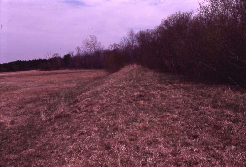
Sixteen miles of the Murdock Line was graded in 1853, but wasn't finished at that time. Later, the New York and Oswego Midland Railroad used a portion of that railbed from Midway north. Their "Auburn Branch" only made it as far as Scipio. Later still, after the NYO&W (successor to the NYO&M) closed its Auburn branch, it was operated between 1873 and 1876 by the UI&E, then sold to the IA&W, which extended it to Auburn in 1889 and three years later abandoned it. Even later, the Ithaca-Auburn Short Line used that roadbed from Midway north and extended it to Auburn. Yet ... while these six different railroads had their hands on the northern end, the whole time the southernmost four miles of the Murdock Line remained unbuilt-upon, and so deserves listing here. Simon St.Laurent lives in the area and was kind enough to take a photograph of this treeline facing north from Waterwagon Road:

The New York & Portchester consists, on the ground, of exactly one concrete culvert, located in Harrison, NY. A June 24, 1906 NYTimes article says that ground was broken on the Bull estate.
The New York, Boston & Montreal railroad was to have been built out of several existing railroads plus some connections. They built some of the connections, but went bankrupt during the Panic of 1873. Some of the remains are in the Dill Sanctuary, so they are likely to remain in place for many years. Bernie Rudberg and Roger Liller explored the entire length of the line, and have shared some photos with us:
 |
 |
| The end of the roadbed at the junction with the Putnam Branch in Carmel, with Roger standing where the tracks would have been. The Putnam Branch has been greatly lowered by excavation. | Stone work still in the woods in Clove Valley. Those stones have been there since the NYB&M went bankrupt in 1873. |
 |
|
| Stone work in back of a house near Whaley Lake |
The New York, Housatonic & Northern was to have run from Brookfield, CT, to White Plains, NY. A book by Robert Bang, with coauthors John Frank, George Kowanski, and Otto Vondrak, entitled Forgotten Railroads Through Westchester County covers this railroad in detail. A total of 23 miles were graded through Westchester County and Connecticut.
Rich Coffey did some field research. Found much of nothing, but some of something. December 31st, 2014.
The New York, Kingston & Syracuse was a successor to the Rondout & Oswego (which was itself a successor to the Rondout & Utica). They built to Stamford, and graded several miles west, but that grade was never used. More information in the Railroad.NET Unfinished lines in the upper Delaware and Schoharie Valleys thread, specifically this post. The New York Times article of January 22, 1874 goes into great depth about the bankruptcy of the NYK&S. A March 2, 1888 article talks about how Harpersfield sued the U&D because they spent $100,000 (20% of the value of all the property in the town) toward the building of the road through Harpersfield, and then the U&D built on a different route.
Below is an embankment heading southwest through a field, and at the end of the graded portion is this cut. The cut stops abruptly where they ceased grading it.

 (more photos on Flickr)
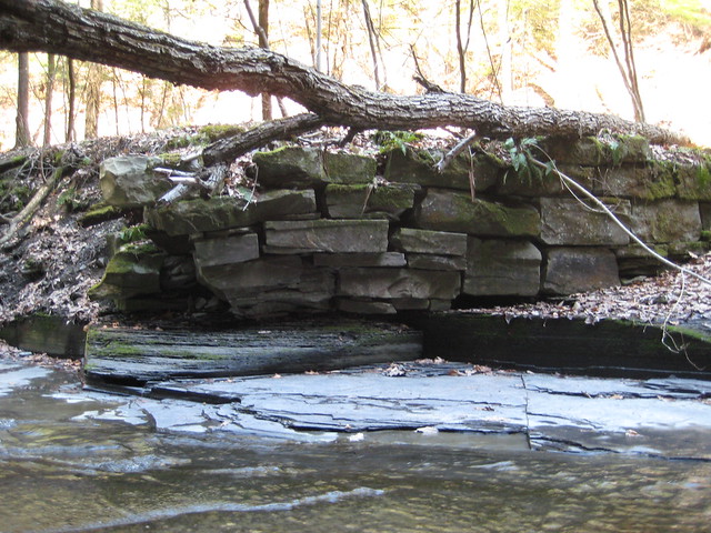
The Ogdensburgh, Clayton & Rome was to have gone through the Black River Valley along the same route as the Black River & Utica, according to the Sapbush Run, by Thomas C. O'Donnell. The rivalry between the two cities was palpable. In this case, Utica won over Rome, because the OC&R was abandoned after being graded up the Lansingkill Gorge. In 1948, O'Donnell said there were sections of grading still visible; in particular a "long embankment running across the Nightingale farm below Dunn Brook". I think I spotted that embankment on the western side of the valley in March of 2009.
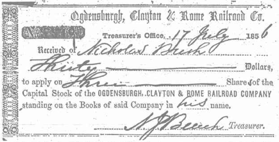
The stock certificate above came from an issue of the Watertown Daily Times, published March 6, 1968:
On Feb. 23, The Times carried an editorial page feature on the old railroad which was seen by James D. Griffin of Glens Falls. He had donated six papers from the O.C.&R., including this stock receipt, to the Jefferson County Historical society. Nicholas Bush, whose name appears on the papers, was his maternal grandfather. Mr. Bush was innkeeper an owner of the Dollinger House in Redwood in the 1850's.
An indirection: I'm not the first person to be interested in the history of this railroad. In 1914, Alexander Soper, the Asian art historian, Hamilton College alumni, founder of Soper-Wheeler, and all-around well-to-do fellow, commissioned essays on "The Attempt to Construct a Line of Railway From Rome to Clayton on the St. Lawrence River." with a first prize of $24 and second prize of $10. Two awards were given. The first was printed in the Rome Daily Sentinel and was brought to my attention by Ron Del
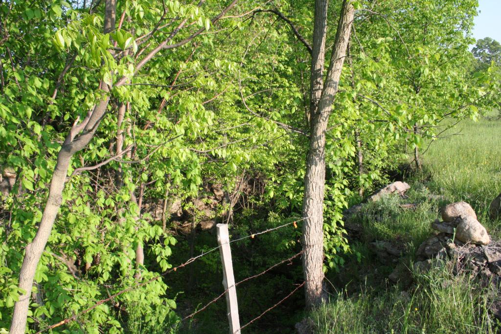
Mumford and Schneider's The Glenfield & Western Railroad talks about the OC&R as well. The G&W's grade used a portion of the OC&R's grade. The book doesn't identify exactly what portions were which. They do say that one of the OC&R cuts was twenty feet wide, twenty feet deep, and fifteen hundred feet long. Lawrence Girard took some photos of this cut at Houseville Road, north on the first, south on the second. Below them are the corresponding locations in March of 2009. You can find trees which match in each one.

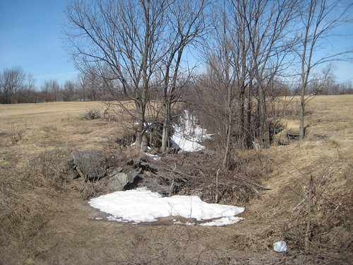
Near Pixley Falls State Park there is some difficult terrain. In order to get past the same escarpment that the falls goes over, the OC&R built (or started to build) a tunnel on the west side of the highway. This is speculation, but looking at the topographic map, it looks like this set of points marks the location of the tunnel on the southern end (AB is the cut to the northern portal, and CD is the cut to the southern portal), and the "cut and abutment" on the northern end (somewhere north of J) All speculation, though. I went there in March of 2009, and it's plausible that there was a tunnel.
Izzy Vosseller has pointed me to another section of the OC&R, this one north of Lowville and south of Castorland, very close to the intersection of 26 and 410.
The History of New York State, Book IV, Chapter II, states
And in [1853] a rival road, The Ogdensburg, Clayton & Rome Railroad Company was projected. The first soon completed its road from Boonville to Utica. The rival road began building operation at various points but completed none. The proposition of two railroads in the same territory, seldom more than a mile part, was absurd, with a result that neither could be finished.which implies that they didn't start at one end, or even from both ends, but instead "various points".
Found an interesting mention in a court action published in the in 1871 (rightmost column). Several mentions of the OC&R in the description of the property lines. One of them I can't figure out even looking at the Lowville village property owners, but the one below runs on a level line right through the current hospital grounds:
Also a certain other piece or parcel of land in Lowville aforesaid, commencing in the centre of the Number Three road so called, in said town, at a point where the centre line of the Ogdensburgh, Clayton & Rome Railroad crosses the said Number Three road ; thence in a north easterly direction along the centre line of said railroad ten hundred and sixteen feet, to the centre of the State road, near Charles D. Boshart's brick dwellinghouse, being a strip of land one hundred feet in width for said ten hundred and sixteen feet and extends forty feet on the westerly side from the centroline of said railroad and sixty feet on the easterly side of said centre line of said railroad, containing two acres and thirty-three hundredths of an acre of land.
From the New York Tribune, November 4, 1853:
From Ogdensburg N[ov]. 1, we learn that the contracts for the grading, masonry, and bridging of the Ogdensburg, Clayton and Rome Railroad were awarded, and the whole work is to be finished by the first of September next, and the rails are to be laid between Rome and Lowville, and be- tween Ogdensburg and Philadelphia, making a distance of about 90 miles, within a year from this day,
 (more photos on Flickr)
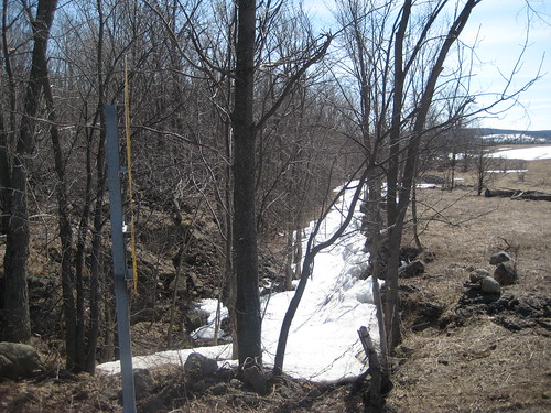
Did some field work in April 2014. Found that the railbed on the north side of Pixley Falls State Park is pretty well defined. Found a culvert which is still carrying water underneath the railbed! And found two eroded sections where there must have been culverts that got blocked, and the water flowed over top and eroded them. Recorded some video.
My understanding, as of November 2014, of what was built goes as follows. They seemed to have done a LOT more work closer to Rome, which is where they were getting their investing from. A lot of grading was done going north out of Rome. They graded (or so I've been told) from their junction in Rome along the east side of the Black River Canal (now Black River Boulevard), crossed the Mohawk, went through the plant nursery on Wright Settlement Road. All of that is now bull-dozed away, although there might be a tiny bit south of Wright Settlement Road.
Then there are treelines which I haven't investigated but which I assume have a railbed underneath them, up to Pennystreet Road. Then it dives into Delta Lake, but you can see the cut it went through about 20' into Delta Lake State Park. Some people think that's the canal, but I'm pretty sure it's the OC&R because you can see the canal elsewhere in the park, and the canal is mapped where you can see it.
There's a hilltop in Delta Lake and between that hilltop and the shore is a narrow shallow place. I think that at the bottom of it is a cut, or at least a pass, where the OC&R was going to run. Coming out of the lake there is nothing to be seen, mostly because there are farmers, and farmers hate railbeds. Even if something was built, it is gone now.
Then, once you start to climb the Lansing Kill gorge, it starts to appear on the west side of the highway, going up the hill. Then it disappears because it had to cross the highway, the canal, and the kill. Then you get into the highly built-up section south of the Five Combines locks. It would have crossed the kill, the canal, and the highway to enter the tunnel whose eastern portal is opposite Pixley Falls entrance.
There must also have been a bridge over the canal and kill at Pixley Falls, but it looks like the highway crossing would have been at grade. Inside the park you can see an embankment that just stops, pointing at the tunnel cut. Follow that embankment and just about when you get to the edge of the park, the embankment disappears. There are a couple of washouts there, where there were probably culverts that got clogged. There is one culvert, though, which didn't. Water still runs through this culvert.
As you go further north, I know of nothing, except that in the village of Boonville, there is a treeline that doesn't line up with the roads around it, but does line up with the mapped route of the railroad. I am only guessing, because there is nothing else to be seen, but I think that's the railbed.
I have no maps of the railroad going through Lewis County, but there are suspicious straight and level lines that could be the railbed. There's a fenceline and a cut on the south side of Sugar River in Talcottville, and a cut on the north side of Sugar River. That indicates that the routing was more towards Locust Grove and Collinsville where there is a stone bridge. There's a different long straight line near Constableville heading towards Turin. They can't both be the OC&R.
Then there is the cut crossing Houseville Road used by the Glenfield & Western. That is known to have been built for the OC&R and is documented in Mumford and Schneider's Glenfield & Western book. There are mentions of the railbed as an existing feature in Lowville, but I have never seen anything. There is a section in Happy Hollow campground in Castorland, with a partially-built culvert.
I know of nothing north of there.
A rarity for this page, the Otselic Valley Railroad was completed between Georgetown Station and Georgetown. They completely graded it, laid rails, and even purchased an engine and car, but never operated it, and ripped it up shortly thereafter. More information on railroad.net and in Taibi and Georges' A Ride Through the Countryside on the Syracuse & Chenango Valley.
Ontrack was supposed to have gone from the Carousel Mall over to the Stadium in Syracuse, NY. Unfortunately, the bridge they were going to use got stalled. They were starting to build the abutments for a bridge over the highway, next to CSX, when CSX noticed its bridge shifting. CSX called a halt to the construction, and the east end of the right-of-way was never completed. The bridge remains where it was delivered, and the ROW remains without tracks.
Update: The transportation center expanded its parking lot, and the steel for the bridge was moved into storage. The city now wants to demolish the storage building, so they are going to sell the steel for scrap at auction.
The Panama Traction Company went from Panama Rocks eastward. Only some portions were graded. Information from Dave Becker, who lives in the area.
Interesting! Art (Aa3rt) Audley has discovered that not only was there an existing "Panama Traction Company", not only was it in Pennsylvania just a bit south of Panama, but it was owned by the same fellow who owned Panama Rocks. There's more information on Railfan.net (be sure to see Page 2 also).

Jeff Davis pointed me to this railbed from Savona to Penn Yan. Seems to have been attempted under three different names. On Aug 24, 1871, Sodus Bay, Corning, and New York Railroad directors meet at Lyons, agree to let an immediate contract for tracks between Savona and Penn Yan. There was a lawsuit in October of 1878 against the Town of Lyons for unpaid interest on SBC&NY bonds issued May 17, 1872. The "American Cyclopaedia" book calls it the Sodus Bay and Corning in 1875. An article on November 13, 1897 calls it the "Penn Yan and Pennsylvania Railroad". A May 19, 1899 New York Times article calls it "The Penn Yan, Lake Keuka and Southern Railroad". I suspect that the third time wasn't the charm. The two companies share five directors in common.
Indeed, it wasn't, because according to the Town of Barrington's master
plan, the railroad was never completed. They also say that the
trestle over Delo Gully (just south of Eggleston's Glen) was completed, and stone foundations there and
in Eggleston's Glen remain. Chapter 3 has this photo:
"An inscription carved into the stone trestle foundation in Delo's Gully. (Photo courtesy of Robert Scharf)".
The ruins of the railroad trestle foundations in Eggleston's Glen, below the waterfall. The trestle these foundations were built to support was never completed.
The 1974 NYSDOT inventory of abandoned railroads states "It was graded from Savona almost to Bradford. Construction took place two different times around the year 1900. Mr. Harry Joint an octagenarian, proprietor of the local hardware store in Savona, and lifelong resident of Savona, stated track was laid in the Village of Savona around 1902. He further stated that the railroad was never completed nor any tracks laid outside the village."
The Eastern Reporter claims that the Sodus Bay and Corning Railroad owned "disconnected rights of way over a portion of its route, and a road-bed partially graded between Savona and Geneva".
The October 10, 1917 edition of the Schuyler County Chronicle has some information on this railroad, but I can't locate a copy.
Pennsylvania and Sodus Bay. Quite a lengthy stretch of this railroad had been graded, all the way from Seneca Falls, past Trumansburg, Ithaca, and down to Hillview. There's a very interesting property line for Taughannock Falls State Park at its westernmost end. The mostly vertical green line is the PnSB ROW. The next two photos show the bridge abutments where it crossed the river. So not only are there remains on the ground, there are remains in the deeds of the area!
More information about the life and death of this line is in "A History of Railroads in Tompkins County" by Hardy Campbell Lee and revised by Winton Rossiter.
William "Toby" Dills took these two photos of the remains at the
Taughannock Falls State Park where the railroad was to have crossed the
river.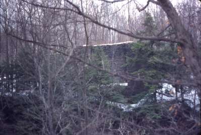
An abutment to the south.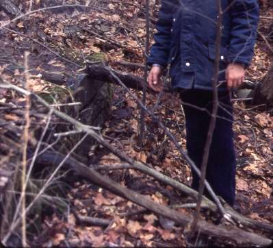
A footing for the abutment on the north.
Another photo from Toby. Like the
others, it was taken some time in 1980 This grade is in Seneca County,
somewhere near Covert.

Cut looking S from
Millard Hill Rd., Newfield. Photo by David Rossiter (brother of Winton
Rossiter), who also did the very nice maps in the Lee and Rossiter book.
The April 23, 1870 issue of the New York Times says "The Pennsylvania and Sodus Bay Railroad Company was yesterday organized by the election of thirteen directors at this place, The road is to run from Waverly, via Trumansburg, Ovid, Seneca Falls and Waterloo to Great Sodus Bay." The February 6, 1873 issue says that the State Senate passed a bill authorizing the Pennsylvania and Sodus Bay Railroad to change its route. The April 16, 1876 issue announces "Railroad Foreclosure", "Judgement of foreclosure and sale against the Pennsylvania and Sodus Bay Railroad was entered into the County Clerk's office yesterday. The railroad runs through Tioga, Tompkins, Seneca, and Wayne Counties of this State. The Union Trust Company of this City is the plaintiff in the suit for foreclosure, it having been made Trustee for the $1,620,000 of mortgage bonds issued by the company.
According to an 1895 History of Huron, New York "In 1850 the Pennsylvania and Sodus Bay Railroad was chartered with Port Glasgow as the northern terminus. Surveys were made and enthusiasm continued with more or less ardor until 1870, when the landable plan was permanently abandoned." (I think the original article said "laudable", not "landable".) James Aitken was the chief engineer of the railroad. That page also says "No rail was ever laid, though all the grading, trestles, fencing, crossing signs and gates etc were put up. Some delay caused the iron rail to not be delivered when it was supposed to be." and "The towns who funded the railway were left with massive debts that the taxpayers spent years paying off." A History of Enfield says that in "1871 $25,000 Bonds purchased March 1st to aid in the construction of the Pennsylvania and Sodus Bay Railroad will become due March 1st, 1909."Dick Palmer found and forwarded this stock certificate to me:

The following image, of the P&SB just south of Newfield, NY along route 13, taken in the 1970's, was posted by Marc Meoff on
railroad.net.
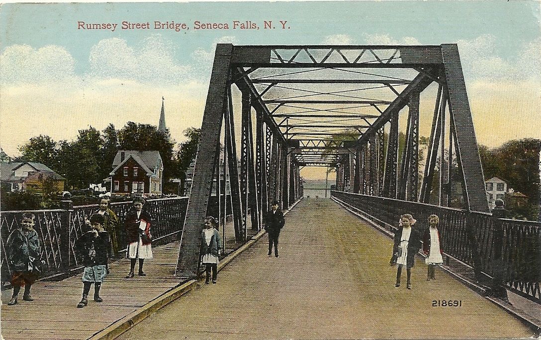
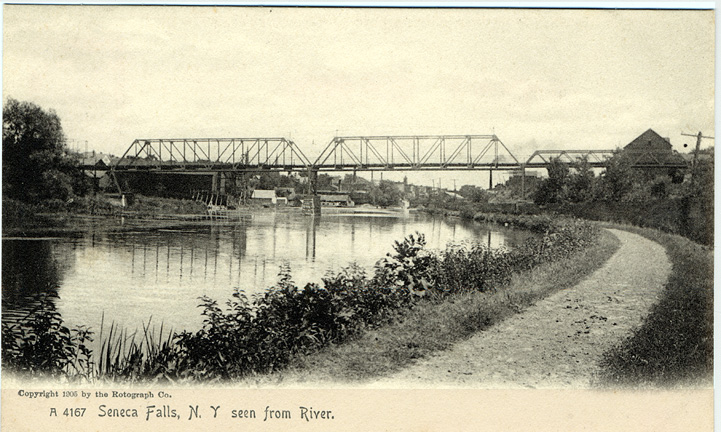
George Vergamini, who grew up in Seneca Falls, says the the original Rumsey Street Bridge was the bridge built for the P&SB, repurposed for a road bridge. Here is a view of that bridge from a pair of postcards that he found:
No route information yet, but there's an article entitled THE ILL-STARRED PB&E--A RAILROAD THAT NEVER RAN by Eleanor Parsons Keagle from the Elmira telegram dated August 8, 1955. It indicates that some construction was done near Binghamton. Also a thread on railroad.net.
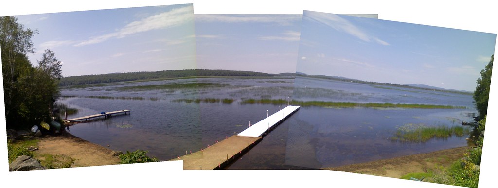
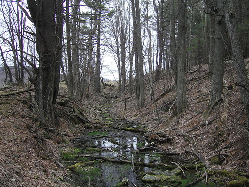
Chris Granger reminded me of Michael Kudish's mention of the Racquette River Railroad. Michael, being a botanist first and foremost, points to the bullrushes in the photo above as the (flooded) railbed of the RRR. It was to have run ten miles from Tupper Lake to Axton Landing. More of the grade may have been built than is depicted. Racquette Pond had a lower level a century ago, and we can observe the known built grade in the village of Tupper Lake disappear under the water.
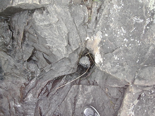
The first photo below shows a blasting hole used to remove material from a rock outcropping above the railbed. The second photo depicts a cut.
More photos on Flickr. I also have a picture of Kudish's infamous bullrushes along with several other blasting holes.
According to Dave Gardner, the Rochester & Eastern Rapid Railway contemplated a spur from Pittsford to Fairport. "Tracks were laid in the village of Fairport and considerable grading was done on this spur, but cars never operated over this spur track which was later abandoned". I have no route information.


Left photo courtesy of Paige Miller from his RN&P set, right photo Bob Melville
I used to have the Rochester, Nunda, and Pennsylvania marked as unfinished. It turns out that Charles Woolever had already corrected me, but I'd missed that. Dick Palmer had to correct me again, pointing out that the RN&P was built from Swains through Rosses and Nunda, Sonyea, and thence to Mount Morris. Charles says it only made it to Sonyea and that it never had revenue traffic. South of Swains to Belvidere it had been graded. That was later sold to the PS&N (that page refers to "other railroad interests" by which they mean this railroad), who finished it.
Two sections of the RN&P were graded north of Cuylerville, along with some masonry work. One was from north of Retsof (which is Foster spelled backwards) to north of Fowlerville. The other is from Clifton to south of West Chili.
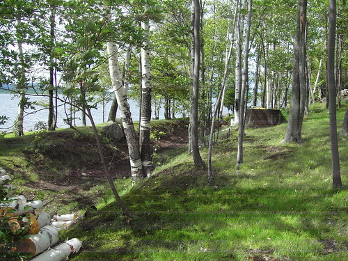
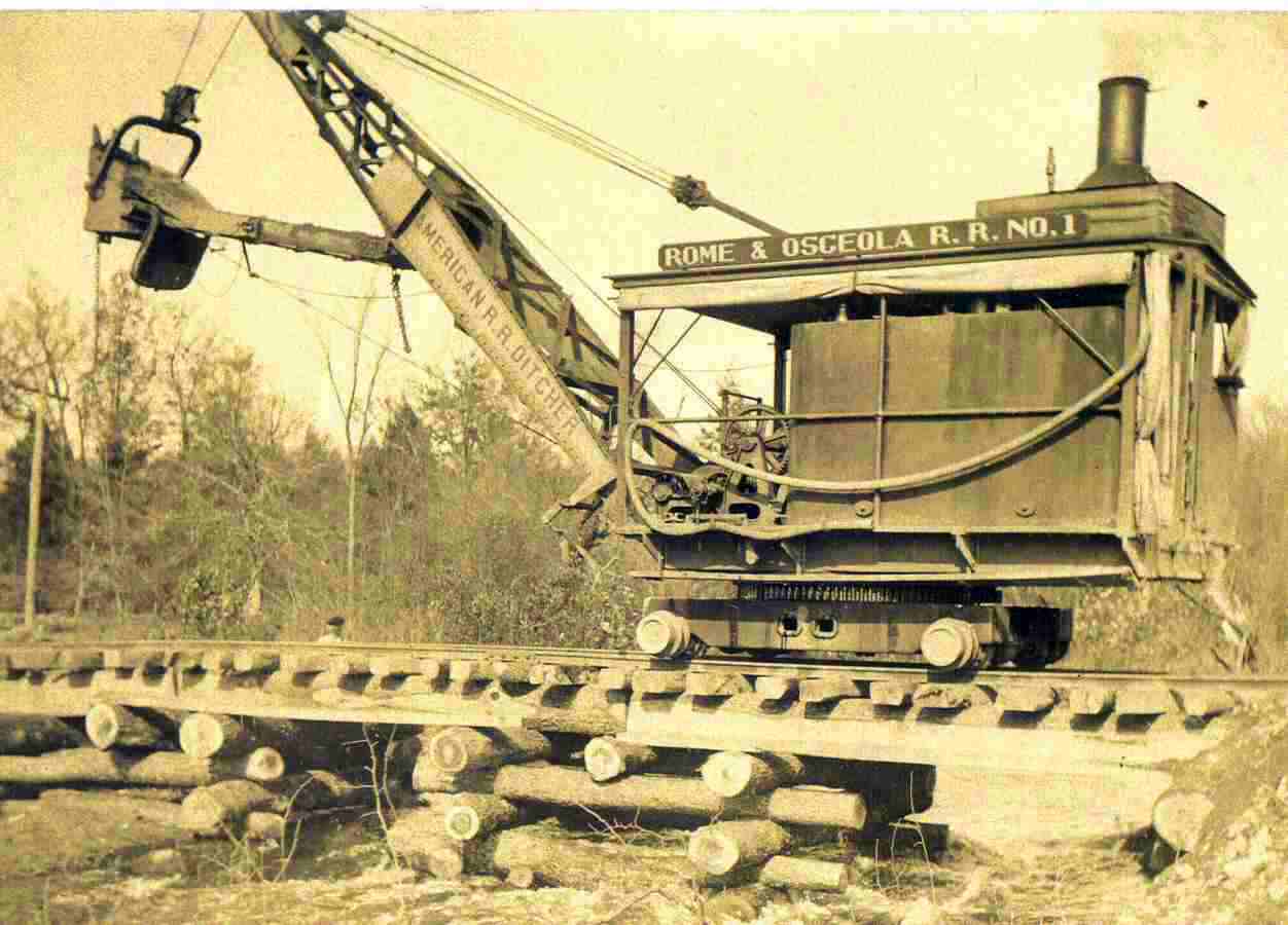
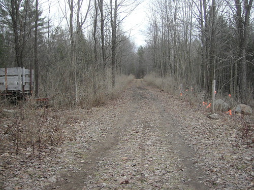
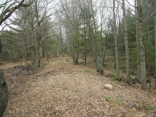
The Rome and Osceola was built from Rome as far north as Lee Center, although this history of Lee Center doesn't make that clear. A fellow who goes by ``ferrology'' implies that it wasn't built to Lee Center. Dick Palmer pointed me to this one. I found a map linked from the Rome Sands Plainpage which clearly said that there was a railroad bordering the Izaak Walton League property. And then finally, joy! The 7.5' topo map labels it as an Old Railroad Grade. Dick says it was graded as far north as Swancott Mill.
Rennie Elliott forwards this photo to me, a copy of which he
received from Ernest Portner who received a copy from someone else.
I did some field-work March 21st 2009. It definitely did NOT look like the railroad reached Lee Center. On the other hand, I definitely found grading on the north side of Lee Center. So my conclusion is that it wasn't built all the way to Lee Center. My pictures on Flickr of the Rome & Osceola.
Update April 21, 2010: Paul De Minco writes to tell me that he used to fish from the RR grade as a youth, and that you can still see rails that fell into the local creek. Sounds like there has been some erosion along the creek that the railroad follows close to Lee Center (Canada Creek). That would explain why so little trace remains of the railbed at Marsh Road.
Paul further tells me that there is a pipeline running east-west through Lee Center! I'm sure that's the right-of-way that I have identified in various places. Sigh. You can see it in the property lines that Google has imported. I think I need to go to the county clerk's office and see if there's a map registered.
Jack Potter points me to these two maps Lee Center and Ava, both of which show the R&O, labeling it as a "proposed railroad".
The prolific Dick Palmer notes that the Sackets Harbor & Saratoga planned to cross the Adirondacks on a north-south route along the Hudson from Saratoga to North Creek, and then an east-west route through Newcomb to Carthage. From the 1854 McAlpine map, it appears that they had planned to follow the Hudson to Indian River, go north of Indian Lake, follow 28 to Racquette Lake, go on the north side of the Fulton Chain, switch over to the Independence River, and head northeast at about Crystal Dale. All guesses from a fairly vague map.
Keith Maloney (author of the Lowville & Beaver River chapter of "Rails in the North Woods") points me to this cut and fill as a portion of the SH&S. Keith's information helped me to locate the cut stone abutment on the south side of McPhilmy Road.
Whenever you're talking about unfinished railroads, there's always a lot of guesswork and uncertainty. If they put a shovel into the earth and you can find it, well, that counts as part of the grading. They might have put in a fill here or there because that's what was easy, rather than having a long contiguous line of grading which is easy to trace like a finished railroad.
I've found several bits of the SH&S grading by staring at topographic maps, expressed in contour lines. With field research, I've backed them up with photos. Going west to east, with reference to this Acme Mapper map:


Jon Patton has done some research on the other end, and has found some grading for the SH&S at the Saratoga County / Warren County border and even more further along Stony Creek (photos).
Jon found, in the Fall 1948 issue of "North Country Life", a four-page article on The Sackets Harbor and Saratoga Railroad, by Ralph N. VanArnam and Lewis S. VanArnam.
There is more information in a page on the Ticonderoga Branch. It says that "Another rail project, the Sackets Harbor & Saratoga Railroad Company began in 1854 with some 30 miles of disconnected sections. Soon, financial issues struck."
This may not be an unfinished railroad at all. Stay tuned.
I have no route information for ths S&W yet. The only evidence of which I am aware are these piers in the Hudson River:
greenwichlirr (Railroad.net user) pointed me to a NYS historical marker in Hudson Falls. The marker reads:
RAILWAY BRIDGE PIERS The large stone piers located below in the Hudson River were placed there in 1837 for the construction of the Saratoga Whitehall Railroad. The bridge was not completed and the railroad stopped work due to the panic of 1838. The only use ever made of these piers was for the Hudson Falls Fire Department to string lines for fire alarm boxes, until the mid 1970's.
Apparently this early railroad helped set a legal precedent: Brintnall v. Saratoga & Whitehall Railroad, 32 Verm. 665".
Hmmm... equally interesting, this page claims that the railroad was eventually finished! Reminiscences of Saratoga and Ballston By William L. Stone. And this page describes a history of Saratoga County, naming the Saratoga and Washington Railroad as the one whose construction was stopped in 1836 (not 1838 as above), and which was later reorganized as the Saratoga and Whitehall.
Wikipedia's article on the Staten Island Tunnel
Ephemeral New York: The tunnel is still there today although its condition may not even be known to the MTA! The NYC Parks Dept. has placed a concrete-slab (chained-down & padlocked) over a tunnel vent and/or access shaft in Owl's Head Park; that "adit" is located roughly 250ft from the southeastern entrance to the Park at Colonial Rd. & 68th Str. Al Thompson says on Facebook's Brooklyn Norwegian page "The abandoned shaft was covered with cement and few people knew that a small cement patch in Bliss Park was a remnant, I was visiting Brooklyn this week and the cement patch at the southwest corner is gone, now a dog run. The shaft is still there although covered."
The New York Times published an article entitled A Subway to Staten Island? It Almost Happened.
John Benton says The main reason why this project never got finished, was because the then governor of New York, Al Smith defunded this project. It was said at the time that the mayor of NYC wasn't "eye to eye", with the Governor regarding funding for this project, as well as some other issues regarding labor etc. In addition to that, Gov Smith ordered both of the portals of this tunnel to be sealed with concrete, both on the Brooklyn and Staten Island sides. (If one knows were to look, you can still find evidence of this unfinished tunnel on both the Brooklyn and Staten Island sides.) About roughly a century ago, it was rumored that Gov Smith defunded this project because he owned stocks of share in the Pennsylvania Railroad, (PRR) the arch rival to the Baltimore & Ohio Railroad. (B&O, later Chessie System)
Also visible on Google 3D aerials
The Suffolk Traction Company was a going concern, which ran between Sayville, Patchogue, and Holtsville. They planned and built most of an extension from Port Jefferson south to Holtsville. The track never made it to Holtsville, although a bridge was built across the Greenport branch of the LIRR. The photo above is the abutment (from Bygone Long Island). The tracks were built in Port Jefferson from the harbor to the LIRR station, but were only ever used for a steam crane during WWI.
Dave Keller did lots of research on that line. He shows the routing on a modern map as far north as Waverly Avenue. I looked on the New York State LIDAR, and found his routing up to Waverly AND routing through the woods north and west of College Road.
Sunk Mine Railroad was an operating 2' narrow gauge mining railroad, pulling iron ore out of what is now Fahnestock State Park. The unfinished part was a branch line going north off their main line. That portion is now easily found by hiking the Appalachian Trail.
Credits: Dick Palmer, Contributors to the Railroad.Net thread, Michael Kudish's Railroads of the Adirondacks, or as noted. Also private communication from Philip M. Goldstein. Know of an unfinished railroad in New York State? All contributions and suggestions gladly entertained.
Gazetteer of the State of New York, published 1860 lists these names, for which I have done a bit of research.
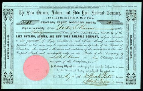